Navigating Resilience in Fairhaven, MA: Insights from Michael Luegering's Advanced Research Studio
Image
This fall at the University of Virginia School of Architecture, 13 graduate landscape architecture, graduate urban design, and undergraduate architecture students enrolled in Assistant Professor Michael Luegering's advanced research studio are exploring the rich history, culture, and changing landscapes of Massachusetts' southern port town of Fairhaven. According to Luegering, the town's coastal future has been advertised to its residents, but not in a productive way. He hopes to explore optimistically and sincerely with his students how climate change can be engaged without fear and gloom.
The studio is supported by a teaching, research, and community engagement initiative, called Envision Resilience Challenge (ERC), developed by ReMain Nantucket, which connects interdisciplinary teams from leading universities with coastal communities to imagine resilient pathways in the face of climate change through adaptive design. UVA is one of seven university partners selected for the third iteration of the ERC taking place in New Bedford and Fairhaven, Massachusetts this fall.
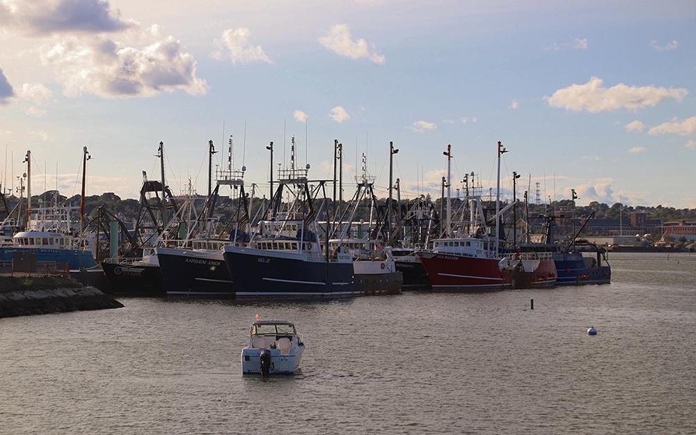
We caught up with Michael and some of his students shortly after they returned from Fairhaven to learn more about the studio's field research in the continually evolving landscapes surrounding one of the largest fishing ports in the United States.
How did you first learn about the Envision Resilience Challenge?
Brad Cantrell, Department Chair of Landscape Architecture, encouraged me to reach out and get involved. Through the application process, Envision Resilience asked for a short prospectus on how we would propose to work in the New Bedford/Fairhaven region, the type of student we’d involve, our ability to travel, and the type of disciplinary insights we might provide.
UVA is joined by Howard University, University of Florida, University of Massachusetts Dartmouth, Rhode Island School of Design, Northeastern University, and University of Massachusetts Amherst. Is there any interaction between the participating universities?
All the faculty did a pre-field trip in June to get the lay of the land. I have developed a rapport with the other instructors, and some of us are going to try to write a paper together. This semester, the seven studios meet over Zoom to attend a speaker series organized by Envision Resilience, and we'll come together virtually to recap and exchange reactions to our respective site visits—share what we saw and how we’re thinking about things. It should be a good conversation.
Did you get to choose a studio site?
I had freedom of choice. When I pitched the idea in the initial application, I identified two areas of Fairhaven—Sconticut Neck and West Island—essentially everything outside of the hurricane barrier, as a point of interest because I really wanted the studio to focus on adaptive land management and migration, topics I take on in my own research and practice. When I went to Fairhaven, I developed relationships with some locals, like M.L. Baron, who is a storm and weather correspondent for WBSM AM 1420. He and his family have been on Sconticut Neck and West Island for generations. He gave me unparalleled insight into the region's rich history and traditions, which is a fascinating part of this place. For example, longtime residents here know what it looks like to have less value embedded in the structure of their homes and more in living in a place—neighbors tow homes back to locations after a hurricane, versus trying to build for permanence.
What’s the history of hurricanes in the region?
Like most places on the Eastern Shore, there have been intermittent small and large hurricanes. A lot of what we’re focusing on is the much smaller stuff, the nor’easters, the regular erosion. But the hurricanes have left a real mark on the region for very particular reasons, some of which are based around capital projects. There was a hurricane in the 1930s that was totally devastating to the entire region, from Connecticut all the way through southern Massachusetts. There was another in the 1950s of note, but not nearly as impactful.
Image
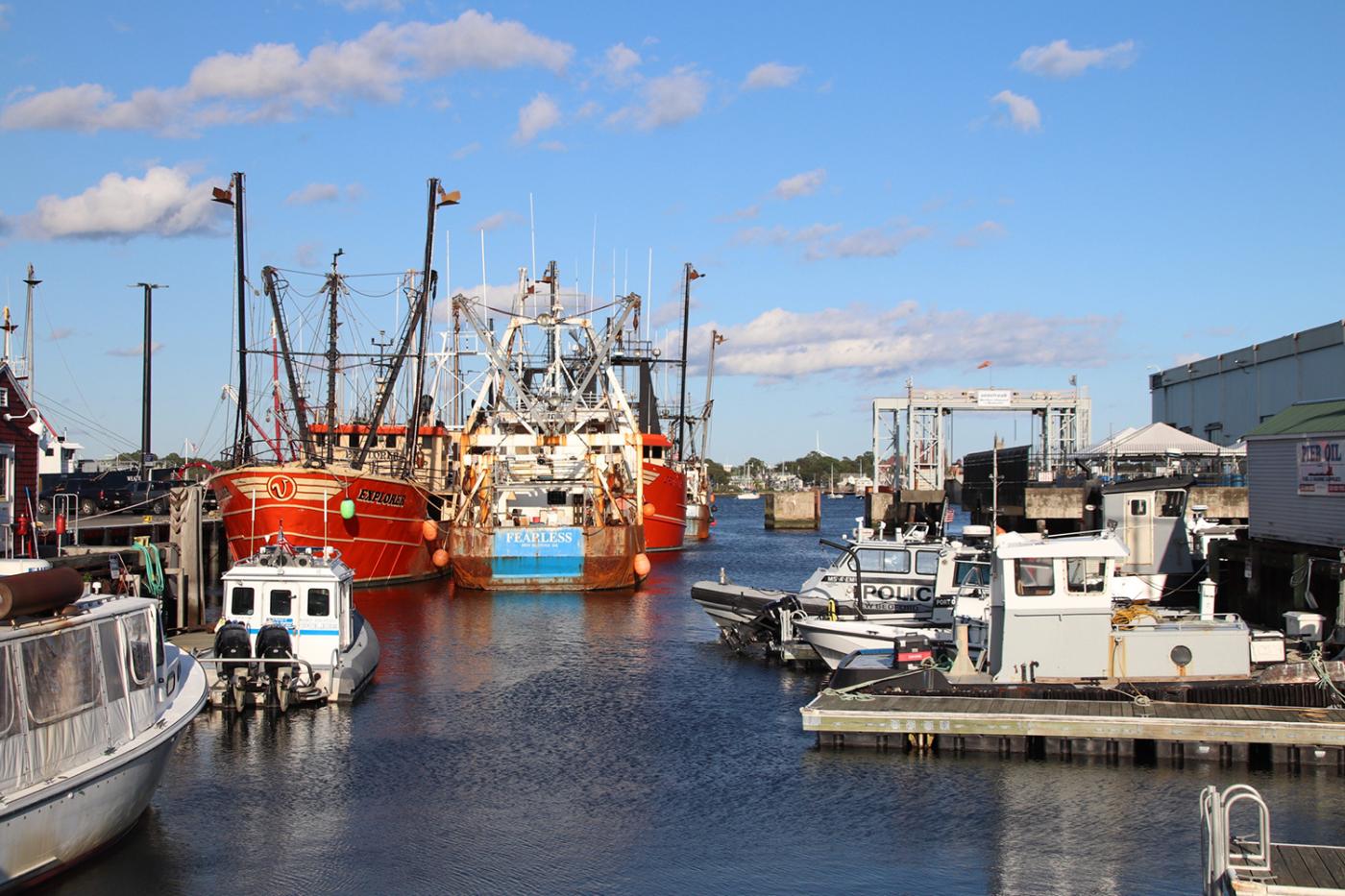
When was the hurricane barricade built?
Planning started in the late 1950s and construction was a decade later. The hurricane barrier is kind of extraordinary in a lot of ways, not to be positive or negative about it, but it’s hard to imagine how big and expansive it is until you get there. New Bedford and Fairhaven is not an inconsequential port by any means, but this is an extremely notable form in the landscape.
While there have been minor hurricanes that have moved through the region, the quote that I hear over and over again is that the wall has never really been tested. It was built in a reaction to a series of devastating storms before it and has since taken on a life of its own. It’s a kind of public space. It's also critically altered the ecology of the region, serving as a water control mechanism in the port. The Acushnet River, which feeds the bay and the harbor, was extremely polluted, and the barricade has controlled to a certain degree how much the river, and therefore the harbor can flush toxins into the bay.
What does your pedagogical process look like? What teaching strategies do you employ?
I asked students for their trust. I took a real risk this semester. Typically, I would start with theory and provocation. I started that way with a bit of a hedge to see where students were coming from to maximize their skill sets.
There's a heavy emphasis on iteration in the studio. In the students' shared working files I will input notes from our desk crits, like, I think you should draw something like this or here's a project you should research. I think it's easier to be more more direct and engaging on a 1:1 or 1:3 basis, than a blanket brief for everyone.
Probably the most critical thing I’ve changed in my approach to this class is that we don’t talk about anything we don’t need to talk about ahead of time. The Wood’s Hole Institute, one of the finest oceanographic institutes in the world has been doing a resilience analysis study for New Bedford and Fairhaven for the last year and a half, and those results are available online. I specifically did not make note of it in my studio brief. When I showed the study to everyone in early October, their reaction was: “Why wouldn’t you give this to us first?”
One of the reasons was exactly this: it presumes that the society that lives there in 2070 will want those things to be preserved, they will want to live the same way we’re living now, and they will see that as a priority in relationship to a larger vision for how the region would function. The research is very valid for people making decisions right now, but when designing for a set of future scenarios, the consequences of making decisions can’t fully be understood without thinking about a whole other set of effects that will form Fairhaven in the future. The survey is valuable information, but it lacks the framing and position to really consider a larger vision and totality of how a landscape might evolve and the hard choices you might make. It’s a great list, but no list ever goes totally checked, and it lacks the cultural position.
What is the time frame that students are considering with their projects?
Some students are looking at things to be instantiated immediately for the next 10 years, other students are setting a series of scenarios that are freeze-framed in 2070 as they imagine those scenarios to emerge. Their concerted thoughts are based on their position with the Fairhaven landscape. For example, a couple of my students are looking at the narrows, which are already seeing force flooding in winter. There’s a potential immediacy, but there are also long-term processes to consider.
I really want students to think about future scenarios: What if Fairhaven starts to recede over time? What if Fairhaven doesn’t have the federal funding to provide disaster-related infrastructure? What if the hurricane barrier is now too low due to sea level rise? Some of them seem a little dark, but they’re not unrealistic.
Image
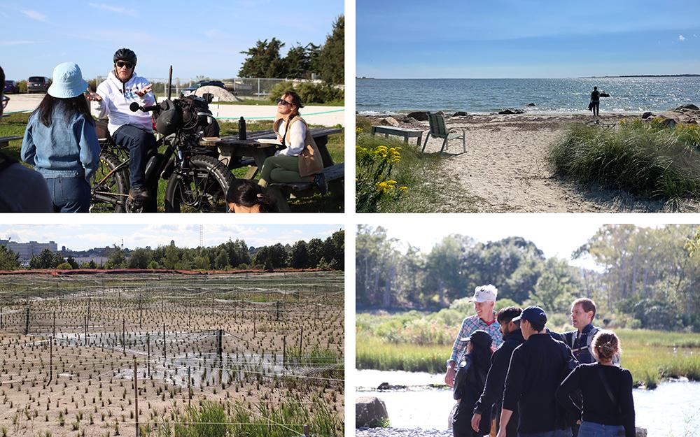
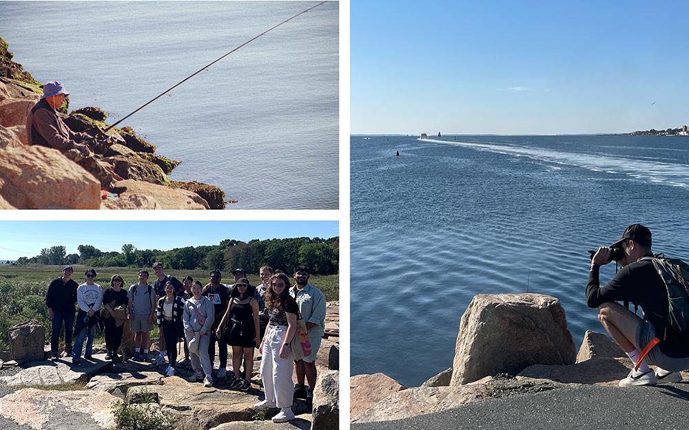
What were the highlights of your recent studio trip to Fairhaven?
We walked almost the entire shoreline. In my opinion, it's the only way to really feel the scale of the place and…I know this sounds very corny, but be a great landscape detective. For instance, the plants can tell us a lot about how things are changing that the data doesn't yet represent, and so the only way you can really see it is on your feet.
Our trip began at a restoration project managed by Buzzard’s Bay Coalition. The project abuts Riverside Cemetery, which was built by FDR’s grandfather and contains the Delano family tomb (the Delano family is from Fairhaven). There are notable people, earthen forms, and mausoleums in this ground, but we also wanted to see the low-lying areas there, which are poised to change. You can already kind of see it. It's a very interesting speculative question: how would you evolve this type of landscape, knowing that it is inherently very designed, into the next century of memorial, and the next century of climate change? Life will go on generally as we know it, but what are we expecting, or what could we think about changing that would allow us to embrace that as a community? What better way than in a place where people go to see and think and remember?
Other highlights included a visit to West Island, where we met with M.L. and saw the causeway—which gets overtopped a couple times a year—that connects the island to Sconticut Neck. And we had great meetings with local experts, like Josh Crabb from the Department of Public Works, who spoke about the roadways and sand inundation issues in low-lying areas, Carolyn Longworth, a local historian and former director of the Millicent Library, and Claire Martin, project manager of Envision Resilience, who got to learn what the students have been looking at in the field.
Are there any plants that you and your students became fascinated by when studying the adaptability and resilience of this coastal landscape?
I can say with a lot of pride that all the students in this studio can identify phragmites in the field now. And they’re starting to speak knowledgeably about what the phragmites represent—a strong indicator of a moisture gradient change and an ability to outcompete “native” vegetation at low salt levels. In the field, I talked about identifying low salt-tolerant plants that live at the edges of marshes and can help indicate where salt water has moved or is moving over time. We discussed high marsh plants, things like Iva frutescens, Jesuits bark, or Baccharis halimafolia, because they are incredibly hardy. We also talked about how a plant’s features tell you about what they're experiencing. Wind shaping was a big part of our conversations. I think a bunch of students have pictures of me holding my arms up and demonstrating. I get a little bit into it in the field, and I forget what I look like.
Do you think you might apply to do this again?
I would love to. Yeah, I've had a blast doing this. First and foremost, I hope my students learn a lot.
A few of Luegering's students shared their thoughts about the studio trip and how they envision resilience for Fairhaven.
Pandora Zhang, BS Arch ‘24: The studio trip allowed me to better understand Fairhaven's culture and locals’ daily activities. For instance, residents enjoy watching the water from their car, while sipping their morning coffee and reading the newspaper. You cannot find this information online. It might seem like unimportant information, but it hinted at the love Fairhaveners have for the coast. It's a beautiful landscape.
This semester I’m investigating a section of Sconticut Neck called the narrows, a thin stretch of land susceptible to flooding. The breaching of this landmass will cause major issues in the water health since the peninsula of Sconticut Neck divides two bodies of water—one healthy and the other in poor condition. My approach to envisioning resilience for Fairhaven is to accept the change that is happening by creating interactive landscapes that can still be enjoyed during seasonal flooding.
Image
Emma Potter, MLA ‘24: My project site is located on an EPA Superfund remediation area in Fairhaven. The former factory, Atlas Tack, operated within the confines of an urban neighborhood from 1901–1985 and remained untouched until the EPA stepped in in 2007. Technically, the site is considered fully remediated but it remains as an isolated vestibule, located on the northern side of a massive levee that was once intended to serve as a hurricane barrier. This now recreational infrastructure fractures the once biodiverse salt marsh and the urban fabric of the residential community.
Image
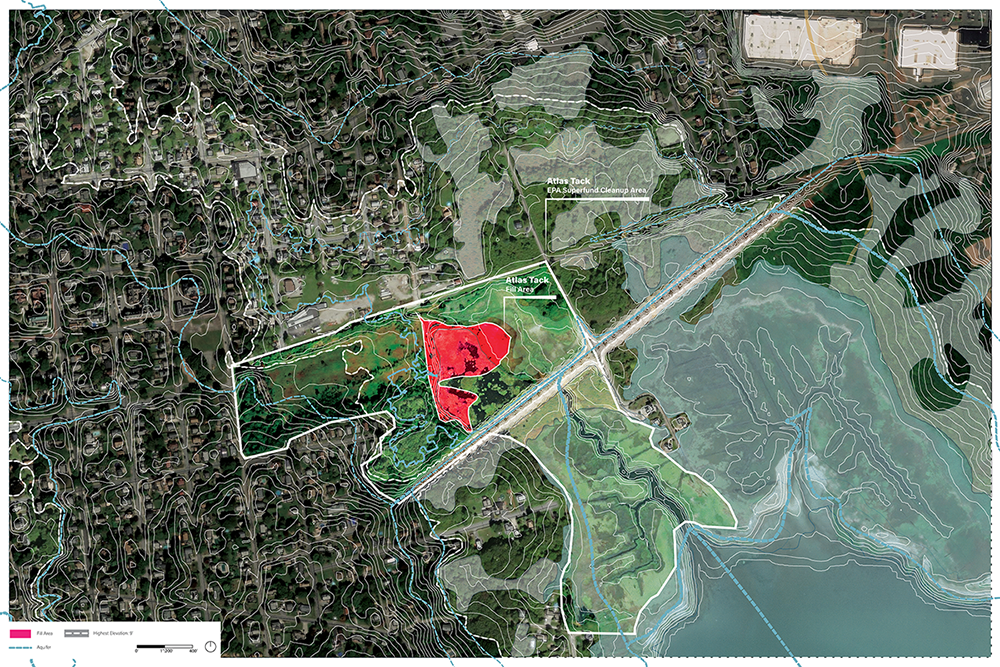
The key focus area of my project spatializes the built freshwater pond that lays atop of an excavated fill location and freshwater aquifer that feeds the saltwater marsh. The purpose of the pond is to ensure an adequate balance of salt to freshwater to support the native plants in the salt marsh. My project presents an opportunity to engage with the migrating aquatic landscape and provides a smoother transition of water inundation into a residential community as, ultimately, this is a coastal landscape that will continue to face an increase in flooding throughout the coming years.
The final design proposals from the seven university teams are featured in the exhibition Envision Resilience: Designs for Living with Rising Seas on view at the New Bedford Art Museum, January 20–March 24, 2024.