

Networked Public Space Shortlisted for the Plan Award 2024
Image
THE PLAN Award is an annual international prize that recognizes excellence in architecture, interior design, and urban planning. With twenty different categories and over a thousand submissions every year, THE PLAN Award is an important opportunity for architects, designers, urban planners, and planners to participate in an international community and contribute to the discussion of the key issues affecting the industry today.
The quality of this competition is underscored by its international jury, made up of leading figures in the architecture, design, real estate, and academic fields. For the 2024 award cycle, the UVA School of Architecture's Networked Public Space has been shortlisted for this exciting peer-evaluated recognition. Networked Public Space (NPS) is a research project led by Associate Professors Mona El Khafif and Andrew Mondschein with support by the research team including Luis Felipe Rosado Murillo, Davis Eddy, and Darcy Engle.
Cast your Vote for NPS
Through September 30, 2024, shortlisted projects can be voted on by the public for the Community Wish List Special Prize. Cast as many votes for the same or multiple projects as you would like.
|
Image
|
Image
|
Networked Public Space: addressing issues of urban sustainability and environmental justice
Project Narrative by the Research Team
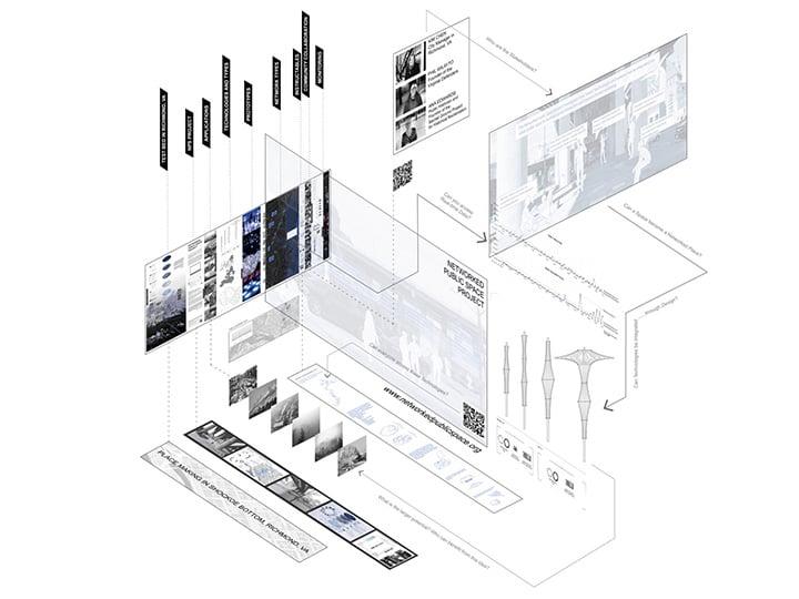
The idea for Networked Public Space (NPS) came from conversations with community members, who described concerns about their surrounding environment while questioning the value and safety of environmental data collected from sensor networks. These dialogues highlighted (1) the absence of effective public space strategies for making environmental information legible to community members, and (2) the importance of mediators, like designers and planners, in ensuring that environmental data are used to empower local communities. The responsive public space architecture and data network that makeup NPS address those problems. NPS is open-source, scalable, accessible, and geared to engage historically excluded communities. NPS puts data, analysis, and meaning generation into tactical and democratic contexts.
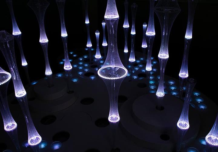
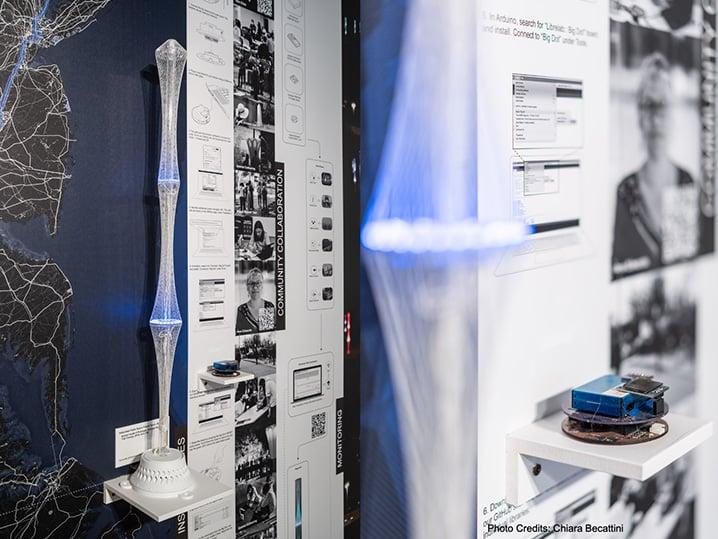
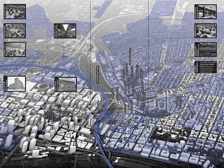
The project is a public space installation, tested first in an indoor location and then deployed twice as part of the Gabriel Celebrations held in the African Burial Ground in Shockoe Bottom and once as part of the InLight public art exhibition at Great Shiplock Park. The components of the project are responsive lighting elements and environmental sensors. The lighting elements respond to changing environmental conditions. The choice of sensed environmental data varied each time based on community stakeholder input, including nitrogen oxide, particulate matter, noise, and motion. The project fused environmental and social justice movements, making the impacts of urban renewal and highway construction visible in the context of longstanding racist oppression in the neighborhood and sites.
Image

The project is not fabricated out of sustainable material but features noise and air pollution issues through environmental sensing. Hence, as a tool and system approach it is addressing issues of urban sustainability and environmental justice. The project has no certificates, but we share all data and codes publicly as open-source access and Instructables. The project was exhibited at ECC Venice Biennale 2023 and is featured in research papers and book publications.
Through legible and responsive public sensing design, Networked Public Space mediates between community-driven environmental resilience and justice and data-driven environmental planning. A critical, unresolved problem for urban technology is bridging data analytics with the creative design of public spaces - the most essential physical and social environment of our cities. Rather than focus on efficiency and optimization, the NPS project explores how data-responsive urban design and infrastructure can deepen human relationships with their environment and empower individuals to take on the social and environmental challenges facing communities everywhere. NPS bridges the efforts of residents to enhance their communities and governmental and private management of public space and infrastructure. The environmental sensing installation measures environmental conditions in real-time, responding to conditions on site with changes in lighting, and also uploading the data for visualization online. These responsive sculptures bring environmental justice issues into conversation with the work of social justice activists. They highlight the history of the African Burial Ground that extends to its conditions today, from the erasure of “urban renewal” and construction of I-95 to ongoing air and noise pollution on the site. The sensors measured these pollutants and made them part of the visible fabric of urban space.
"There is a beautiful, illuminated line of columns crossing the burial ground. These are sensors designed to pick up the particles and pollutants in the air around us. If you are living in a neighborhood that is experiencing this kind of pollution, (...) this is open-access technology that you can create to track this information in your communities and to make your case, when you need to prove that something is not right (...)."
— Ana Edwards, Sacred Grounds Historical Reclamation Project
Image
Credits
Locations: Prototype 1 Charlottesville, VA; Prototypes 2, 3: Richmond, VA; Prototype 4: Venice, Italy
Clients: Community Partners: Center for Civic Innovation (Charlottesville, Virginia), Belmont- Carlton Neighborhood Association (Charlottesville, Virginia), Jefferson Area Board for Aging (Charlottesville, Virginia), C4K (Charlottesville, Virginia), City of Richmond, Virginia
Completion: 11/2023
Architects: Mona El Khafif, Davis Eddy, Darcy Engle, Andrew Mondschein
Design team: Gabe Andrade (2019-2020), Marian Roshdy, Cara Hu, Wesley Jonah Lewis, Teagan Le (2020-2021), Pryce Derek Foyt, Brian Kusiak (2020-2021); With support from The FabLab at the UVA School of Architecture
Consultants: Luis Felipe Rosado Murillo (sensor technology), Jonathan Michael Kropko (open data), Ali Sareini (data dashboard), Seshi Konu (community engagement)
Photo Credits: Tom Daly, Davis Eddy, Mona El Khafif, Chiara Becattini
Co-leads: Mona El Khafif, PhD is an Associate Professor at UVA School of Architecture and Director of the Urban Design Program. Her research operates at multiple scales, examining the interdisciplinary aspects of urban design, temporary urbanism, urban prototyping, and strategies for the smart city. Andrew Mondschein, PhD AICP, is an Associate Professor of Urban and Environmental Planning at the University of Virginia School of Architecture. His research emphasizes the role of information and knowledge in fostering individual- and community-level agency over urban life and the environment.
THE PLAN Award International Jury
Amale Andraos, WorkAC and Columbia GSAPP
Jennifer Beningfield, OpenStudio Architects
Alvin Huang, Synthesis Design + Architecture and USC
Sebastian Irarrazaval, Sebastian Irarrazaval Arquitectos
Hana Kassem, KPF
Xiangning Li, Tongji University
Rahul Mehrotra, RMA Architects and Harvard GSD
Taraneh Meshkani, Kent State University
Valerie Mulvin, McMullough Mulvin Architects
Jean Baptiste Pietri, Pietri Architects
Peter Rich, Peter Rich Architects
Raymund Ryan, Heinz Architectural Center, Carnegie Museum of Art
Yehuda Safran, Pratt Institute
Elena Tomasi, FPMC
Xiaochun Zhang, Tongji University

